

Poplar Point Plan
Thank you to all the residents and community members who have engaged on the Poplar Point Planning process to date. The District continues to work with the National Park Service on the Draft Environmental Assessment (EA) which will be released for public comment.
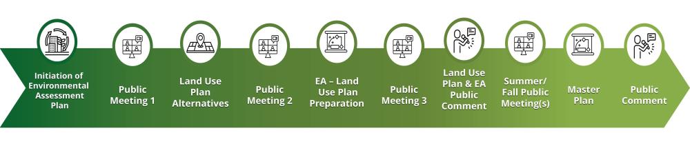
Following the close of the EA public comment period, the District will advance the Poplar Point Master Plan. The Master Plan will build on the land use plan established in the EA, detailing the anticipated development program for the site including building uses, parks and open space programming, and roadway and street network design.
Updates on the EA release date and upcoming steps will be shared on this project website.
The Poplar Point Plan is being developed in partnership between the District of Columbia government and the National Park Service. The redevelopment of Poplar Point will be determined through this process and ultimately include preserved and improved wetlands and natural areas, a mix of development uses including housing and community amenities, and improved connections between the site and the surrounding communities. The planning process includes a Master Plan and Environmental Assessment, which are required to complete a land transfer between the NPS and the DC government.
Project Overview
Poplar Point is an approximately 110-acre parcel located along the east side of the Anacostia River between the Frederick Douglass Bridge and the 11th Street Bridges in Washington, DC. Poplar Point is bound by the 11th Street Bridges to the north, the Anacostia Freeway (Interstate 295) and Suitland Parkway to the east and south, respectively, and the Frederick Douglass Memorial Bridge to the west.
Poplar Point is currently under the National Park Service (NPS) jurisdiction and consists of a mix of accessible open space, wetlands and natural areas, abandoned remains of former greenhouses and other government facilities, as well as the NPS’s current administrative and law enforcement facilities.
In 2006, Congress enacted legislation (Public Law 109-396, commonly referred to as the DC Lands Act) directing the United States to transfer the NPS property at Poplar Point to the District of Columbia. For the land transfer to occur, the DC Lands Act requires:
Preserving at least 70 acres for park purposes;
Identifying the NPS facilities and their relocation sites;
Allocating two locations for federal memorials; and,
Completing a land use plan.
Poplar Point Plan Process and Timeline
Throughout the process, there will be public meetings and multiple opportunities to share your feedback and input. Your participation is vital to the success of this planning effort.
-
 Briefing Files
-
 Poplar Point 9-29 ANC-CBO Briefing Presentation.pdf (2.32 MB) (pdf)
-
Poplar Point 9-29 ANC-CBO Briefing Recording.mp4 (77.6 MB) (mp4)
-
Poplar Point 6-26 ANC-CBO Briefing Presentation.pdf (4.97 MB) (pdf)
-
Poplar Point 6-26 ANC-CBO Briefing Recording.vtt (37.8 KB) (vtt)
-
Poplar Point Plan 5-13 Open House Presentation.pdf (3.15 MB) (pdf)
-
Poplar Point Plan 5-13 Open House Boards.pdf (8.55 MB) (pdf)
-
Poplar Point Plan 3-18 Open House Boards.pdf (9.3 MB) (pdf)
-
Poplar Point 2-11 Kickoff Webinar Presentation_1589c3c0.pdf (5.91 MB) (pdf)
-
Poplar Point Plan 3-10 ANC Briefing Presentation.pdf (9.61 MB) (pdf)
-

-
Communications
-
Poplar Point 6-26 Project Flyer.pdf (212 KB) (pdf)
-
Poplar Point 5-7 Comment Period Social Media Post.jpg (4.57 MB) (jpg)
-
Poplar Point 5-13 Open House Flyer.pdf (4.9 MB) (pdf)
-
Poplar Point 4-18 Comment Period Social Media Post 2.jpg (1.92 MB) (jpg)
-
Poplar Point 4-18 Comment Period Social Media Post 1.jpg (2.96 MB) (jpg)
-
Poplar Point 4-5 Walkshop Flyer.pdf (1.73 MB) (pdf)
-
Poplar Point 3-18 Open House Social Media Post.png (286 KB) (png)
-
Poplar Point 3-18 Open House Flyer.pdf (2.5 MB) (pdf)
-